
It would be difficult to find someone who could complain about the amount of snow the Western U.S. has been getting this season, but with powder comes problems. High winds and a combination of surface and deep snowpack instabilities keep rearing their heads and elevating the avalanche danger to high. This week is a time to play it safe. Check with your local avalanche forecasting center to ensure you know what aspects and elevations are creating heightened danger problems before you head into the bc to ski. Here is the avy report for this week.
Crested Butte Avalanche Center (CBAC)/Colorado Avalanche Information Center (CAIC)
Fresh snow is raising the avalanche danger rating to considerable this week across portions of Colorado with more southern areas listed at moderate. New precipitation is causing a few problems; the primary concerns being reactive windslab and a near-surface facet layer in certain regions. The CAIC mentions on their website that with Colorado experiencing a recent spell of mild weather, the threat of persistent lab was, until recently, decreasing. However, with new snow, slab avalanches could step down to this deeper layer and prove extremely dangerous.
“Steering around wind-loaded pockets, and mid-slope convexities will help minimize the likelihood of triggering one of these avalanches,” The CAIC explains for the Gunnison region. “Snowfall is forecast overnight and into tomorrow. Expect dangerous avalanche conditions to continue.”
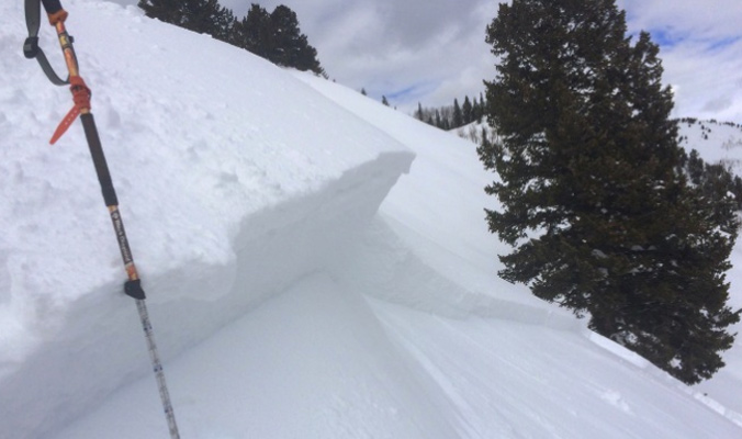
Crown of Persistent Slab avalanche in Steamboat Springs area. [Photo] Courtesy CAIC
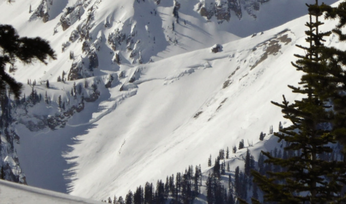
A natural avalanche near a treeline slope in North Anthracite Creek in the Gunnison region. [Photo] Courtesy CAIC
Northwest Avalanche Center (NWAC)
Over the past weekend, the areas under the purview of the NWAC saw a larger amount of new snowfall, with two to three feet of snow accumulating in certain zones. West/southwest winds have created new windslabs that have formed above tree line on a number of different aspects, and are responsible for the rating of considerable avy danger throughout the region. Below tree line, avy danger is rated as moderate, but the NWAC warns that persistent slab is once again a concern as windslabs can step down to deeper instabilities in the snowpack.
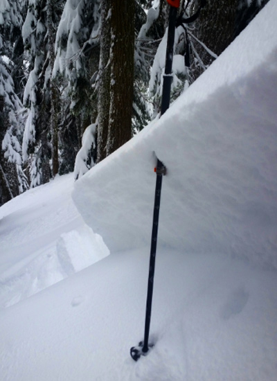
Skier triggered storm slab on Denny Mountain, February 5, 2017. [Photo] Courtesy of NWAC and John Stimberis
To find out more about conditions in the Pacific Northwest, visit www.nwac.us.
Utah Avalanche Center (UAC)
Wind is wreaking havoc in Utah with avalanche danger listed as high for Tuesday, February 7, due to the likelihood of triggering a windslab at elevations above tree line. Also contributing to the high avalanche danger on certain northern-facing slopes below tree line: rain falling on already saturated snow, which is likely to cause wet avalanches.
“Stay off and out from under slopes steeper than 30 degrees, avoid potential avalanche runouts and historic avalanche paths,” the UAC recommends for managing the risk of wet avalanches.
For resort goers, the UAC cautions, “If you step out of bounds at a ski resort, you’re stepping into HIGH danger.” And for climbers: “Many ice climbs in Little Cottonwood Canyon and Provo Canyon are directly in avalanche paths from above. With increasing temperatures and rain up to 7,500 feet, it’s best to avoid climbing in those areas.”
To find out more about conditions in Utah, visit utahavalanchecenter.org.
Gallatin National Forest Avalanche Center (GNFAC)
The Southern Gallatin and Madison Ranges as well as the Cooke City area are currently rated as having high avy danger due to more than a foot of new, heavy snow that has fallen in the last three days. Twenty- to 25-mile-per-hour winds accompanied the storm, with some gusts getting up to 60 mph.
“On Sunday, outside Cooke City, a large natural avalanche in Sheep Creek and two human triggered slides were a preview of today’s main attraction: an avalanche warning,” the GNFAC explains. “Heavy snow and strong winds points to natural avalanches breaking on all aspects and elevations.”
Other regions under the purview of the GNFAC have been affected by new snow and strong winds, but to a lesser degree, with the Bridger Range listed as considerable, and the Northern Gallatin and Madison Ranges listed as moderate.
To find out more about conditions in Montana, visit www.mtavalanche.com.
Bridger Teton National Forest Avalanche Center (BTAC)
The regions of Wyoming under the purview of the BTAC have seen a lot of new snow, with six to eight inches of precipitation reported in the last 24 hours. The new snow falling on buried surface hoar is responsible for the current avy danger rating of high throughout the BTAC region at all elevations. This facet layer, combined with forming windslabs, pose the primary threats of snowpack instability.
“Close to three inches of snow water equivalent has been added to the snowpack since Wednesday,” the BTAC reports. “This load may be sufficient to see avalanche activity failing on buried layers of surface hoar and near surface facets that formed in January, which could increase slab depths by a foot or more. Deep hard slabs are also a concern on high, north facing terrain.”
To find out more about conditions in Wyoming, visit www.jhavalanche.org.
Sierra Avalanche Center (SAC)
The Sierra are also experiencing a bout of high avy danger this week, with wet slides and windslab the primary cause for concern. It is a similar story here as has been reported in other areas across the West. New snow and high winds have resulted in the likelihood for slab avalanches near and above tree line.
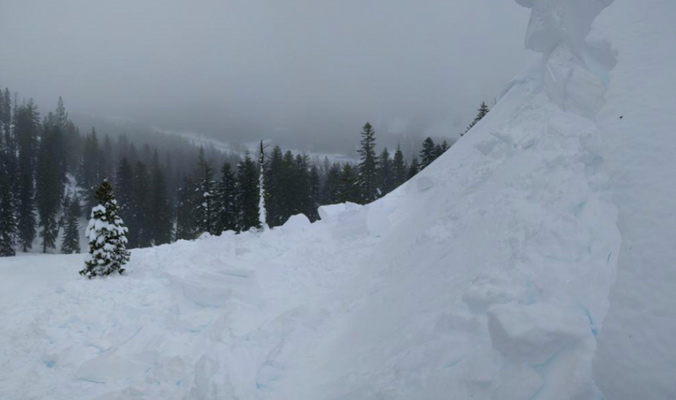
Cornice and avalanche debris from Donner Summit, February 7, 2017. [Photo] Courtesy SAC
To find out more about conditions in California, visit http://www.sierraavalanchecenter.org.
—
As the winter progresses, it’s important to keep an eye on snowpack trends and instabilities. This is not a complete guide to avalanche forecasts, so stay informed and educated by visiting local avalanche forecasting websites and get educated about avalanche safety through programs like Know Before You Go, the Mountain Academy hosted by Salomon and Atomic and through nationwide courses offered by the American Institute for Avalanche Research and Education (AIARE).


Related posts: