
New Year, same snowpack. That’s generally the trend across the U.S., where persistent, early season hazards seem to remain a concern, offering up moderate avalanche danger ratings across many forecasted zones. The far-western part of the country—Tahoe specifically—will see heavy snow over the beginning half of the week, while much of the intermountain west will see snow midweek.
Here’s the regional report for this week.
COLORADO AVALANCHE INFORMATION CENTER
What do Colorado and the month of January have in common? Persistent slabs—they’re the widespread, primary avalanche concern throughout eight of the state’s forecast regions. Storm slabs are of top concern in the Steamboat/Flat Top and South San Juan regions, which each recently received six inches of new snow.
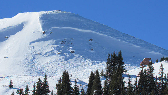
A wind-slab avalanche from late December on a northeast-facing slope in Colorado’s Vail/Summit zone. [Photo] Courtesy Colorado Avalanche Information Center
“It’s the kind of feedback that’s all too irregular in the backcountry,” the forecast states. “It’s a reminder not to underestimate the dangers of choosing lines above trees and other terrain traps that can magnify the consequences of a slide. We can often—usually—ignore that precaution and get away with it. But the exceptions, like this incident, can be rough and even fatal lessons. Best to adhere to that protocol consistently.”
New snow is expected in Colorado this week. Keep up with its impact on the snowpack at avalanche.state.co.us.
SIERRA AVALANCHE CENTER
The central Sierra are in the throes of a significant snowstorm, having accumulated two to six inches of snowfall on Sunday evening with heavy winds and up to 16 inches of snow predicted through mid-week. As of Monday, wind slabs, which are expected to grow to three feet deep, are the primary stability concern near and above tree line.
“More snow load means that the persistent weak layers near the 12/15 rain crust should become easier to trigger today than they have been for the last two days,” Monday’s forecast states, referencing the secondary avalanche problem: persistent slab.
Snow stability throughout the Sierra will increase over the next several days, so read more at sierraavalanchecenter.org.
SAWTOOTH AVALANCHE CENTER
Avalanche danger throughout the Sawtooth Avalanche Center’s five forecasted ranges lies at low at lower elevations and moderate at all aspects of upper and middle elevations.
“A series of weak layers that formed between storms may be found in the middle of the snowpack (one- to three-feet deep),” Monday’s forecast for the Sawtooth Range states. Bulletins for other Idaho ranges read similarly. “The most likely area to trigger a slab avalanche today is where a wind slab sits on one of these buried weak layers.”
Read more forecasts for the Sawtooth Mountains at sawtoothavalanche.com.
GALLATIN NATIONAL FOREST AVALANCHE CENTER
That pesky persistent weak layer is sticking around in Montana, buried beneath slabs three to seven feet thick that caused several destructive avalanches last week. According to the general forecast discussion, snowfall and heavy wind loading triggered significant slides near Cooke City.
“Without recent heavy snowfall and wind loading, it will be difficult to trigger one of these slabs,” the discussion states, “but doing so will have high consequences.”
Here’s a look at the shallow and weak snowpack structure near Bridger Bowl from December 30, from forecaster Eric Knoff.
Still Bad on Saddle Peak by AvalancheGuys on youtube.com.
Check up on Montana-area forecasts at mtavalanche.com.
NORTHWEST AVALANCHE CENTER
As of Monday, January 2, wind slabs are the primary concern across much of the Northwest Avalanche Center’s forecast area, with underlying concerns for persistent slabs and storm snow. Avalanche danger remains considerable and high in many locations, particularly on the Cascades’ east slopes.
“A series of storms beginning last Monday have deposited one to two feet of snow over most east slope areas through Friday,” Monday’s report for “East Slopes North” states. Another five to 15 inches on New Year’s Day followed clearing late last week, resulting in widespread observations of skier-triggered collapses and whoomphing.
On December 27, Adam Roberts died in an avalanche near White Pass Ski Area. According to the Northwest Avalanche Center’s report, the slab broke nine inches deep and 375 feet across and ran 325 vertical feet on a buried rain crust in a drainage known as Grand Couloir. Roberts was a well-known Bellingham, Wash.-based skier who frequently appeared in the pages of Backcountry. He was 31.
Travel advice remains conservative for much of Washington, so read up on specific regions at nwac.us.
BRIDGER-TETON AVALANCHE CENTER
Wyoming has its share of wind slabs and persistent weak layers, too, with moderate winds depositing new snow on leeward aspects and basal facets causing threats of large, destructive slides at northerly aspects above 9,000 feet.
On December 29, rescuers recovered the body of Lee Kidd, a snowboarder who went missing in the Grand Targhee sidecountry on December 23. According to the Jackson Hole News & Guide, search dogs found Kidd’s body below a 500-foot cliff, known as Beard’s Wheat Field. Kidd was an employee of Grand Targhee Resort and was 34 years old.
Read more about the Teton snowpack at jhavalanche.org.
UTAH AVALANCHE CENTER
On Monday, conditions are green and yellow for much of Utah—low on lower elevations and moderate at mid and upper elevations trending toward the north and eastern sides of the compass. But snow will fall throughout the day with strong winds to follow, so expect wind slabs and storm slabs to become increasingly prevalent and dangerous.
“The new wind slabs will be sensitive and easy to trigger today, most widespread in upper elevation terrain and along mid elevation ridgelines,” the forecast for the Salt Lake-area mountains states. “Even out of the wind-affected terrain, the new snow will bond poorly to some of the old snow surfaces.
That same forecasts suggests danger could rise to considerable, so keep an eye tuned to utahavalanchecenter.org.
—
This is not a complete guide to avalanche forecasts, so stay informed by visiting avalanche forecasting sites and get educated about avalanche safety through programs like Know Before You Go or nationwide courses, compiled in this handy database.


Related posts: