
Recent avalanche danger trends continue into this week with new snowfall across the west putting added stress on snowpack stability. California and Colorado continue to be pounded by storms, while in the Pacific Northwest, a variety of weather conditions have led to a range of potential threats lurking in the snow. Read more in the avy report for this week. (Note: This forecast may have changed since the writing of this post on Tuesday, January 24.)
Crested Butte Avalanche Center (CBAC)/Colorado Avalanche Information Center (CAIC)
In Colorado, new snow resulted in increased avy danger across the area under the purview of the CAIC. The highest rating exists in the San Juan Mountains, where a warmer storm came through, leaving dense precipitation followed by high winds.
“Snowfall totals for the month in some areas of the zone have seen over 13 inches of water content,” the CAIC explains on their website. “This is a significant amount of weight in only 24 days. To add to the worries, we saw wind gusts over 100 miles per hour on Monday, further complicating an increasingly dangerous situation. With current conditions and the weather forecast in mind, we settle firmly into Avalanche Warning criteria for Tuesday.”
In the more northern regions of Colorado, avy danger is generally listed as considerable, with five to 10 inches of new snow falling in the last few days combined with strong winds that have left storm slabs in their wake.
“Slabs of new and drifted snow one- to four-feet thick have formed on steep slopes. On slopes steeper than about 30 degrees at all elevations, you can trigger slides one to four feet deep that break in the recent snow or at the interface with old snow,” the CAIC reports.
They recommend staying away from avalanche terrain until danger ratings abate.
To find out more about Colorado avalanche conditions, visit avalanche.state.co.us, and cbavalanchecenter.org.
Northwest Avalanche Center (NWAC)
In the Pacific Northwest, swings in temperatures have created a variety of dangers in the snowpack, with warm weather earlier last week leaving a rain crust and cold temperatures in the last few days resulting in surface and near-surface facets in certain areas. These layers, in addition to storm slabs from recent wind events, are the main avalanche concerns. But NWAC believes that clear skies over the next day may help stabilize the snowpack in areas.
To find out more about conditions in the Pacific Northwest, visit www.nwac.us.
Utah Avalanche Center (UAC)
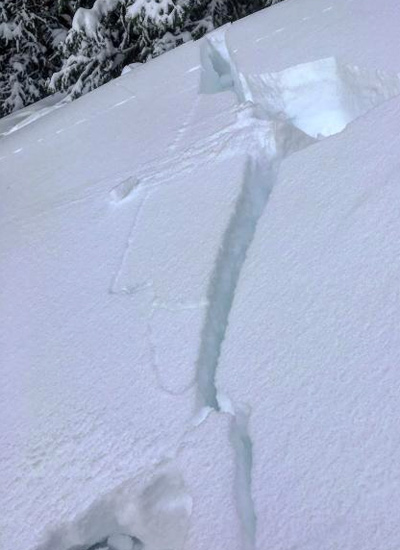
Observation on Mill D North, January 23, 2017. Photo: Courtesy UAC
In the northern regions under the purview of the Utah Avalanche Center, two or more feet of snow have fallen over the last few days, leading to high avalanche danger in the Logan, Ogden, Salt Lake, Provo and Uinta areas, with the Skyline region listed as considerable. The snow that fell was dense, and the added weight of fresh precipitation combined with high winds has proven to be reactive. The UAC warns that these instabilities exist at all elevations and suggest staying away from skiing or traveling under or near any slopes greater than 30 degrees.
To find out more about conditions in Utah, visit utahavalanchecenter.org.
Gallatin National Forest Avalanche Center (GNFAC)
In Montana, avalanche conditions are a bit more favorable, with moderate danger in the Madison, Lionhead and Southern Gallatin Ranges. In the Northern Gallatin Range, avy danger is listed as low as of Tuesday, January 24.
The concerns are related to depth hoar at the ground level and a layer of facets two to three feet below the surface. The main concern expressed by the GNFAC is regarding shallow areas in the snowpack. If a skier triggers an avalanche in one of these areas, an avalanche could step down and result in a very large, deadly slide.
“We believe that on thinner spots of the slope (around edges of the path or near rocky outcroppings) a person might be able to trigger a deep avalanche,” says the GNFAC. “On the upper weak layer, a skier in Beehive Basin got an unstable result in his stability test (ECTP14), a sign that triggering a slide is still possible. For these reasons the avalanche danger is rated moderate on all slopes today.”
To find out more about conditions in Montana, visit www.mtavalanche.com.
Bridger Teton National Forest Avalanche Center (BTAC)
In the Tetons, feet of new snow have left soft slabs on the surface of the snowpack that can be reactive. This snow is prone to sluffing and can be especially dangerous in and around terrain traps. The danger rating currently corresponds to elevation, with below treeline areas rated as having low danger, near treeline areas rated as moderate and above treeline areas rated as considerable.
The BTAC warns, “At the mid and upper elevations, soft slab avalanches could be human triggered on a variety of aspects. These slabs are expected to be up two feet deep and sensitive to ski cuts.”
In the Togwotee Pass area, hard slab avalanches are the primary concern, with areas below treeline rated as having low avalanche danger, and areas above as having moderate danger. This is especially true for north-facing slopes above 9,000 feet.
To find out more about conditions in Wyoming, visit www.jhavalanche.org.
Sierra Avalanche Center (SAC)
Windslabs are widespread across the Sierra/Tahoe area at the beginning of this week. Heavy snow over the weekend left the area with high avalanche danger at all elevations. That rating has since decreased to moderate, but areas of instability still exist in pockets scattered throughout the snowpack. The main areas for concern are near and above treeline.
“Areas of instability will exist within greater surrounding areas of seemingly good stability,” the SAC cautions. “This could create a false sense of security. Avoid relying on marginal islands of safety or grouping up in runout zones.”
To find out more about conditions in California, visit http://www.sierraavalanchecenter.org.
—
As the winter progresses, it’s important to keep an eye on snowpack trends and instabilities. This is not a complete guide to avalanche forecasts, so stay informed and educated by visiting local avalanche forecasting websites and get educated about avalanche safety through programs like Know Before You Go, the Mountain Academy hosted by Salomon and Atomic and through nationwide courses offered by the American Institute for Avalanche Research and Education (AIARE).


Related posts: