
This week, avalanche danger in the west requires a heightened awareness of terrain management. With surface hoar buried under new snow in many locations, and high winds accompanying many storm systems in the last few days, storm slabs are just waiting to be triggered. Here is the avy report for this week to help you make your backcountry decisions.
Crested Butte Avalanche Center (CBAC)/Colorado Avalanche Information Center (CAIC)
Over the last week, Colorado has seen a sizeable avalanche cycle play out on its slopes. In the Crested Butte region, slides were reported on almost all slopes and elevations. This instability was a result of persistent slab that was breaking one- to three-feet deep. This week, this slab still remains a threat and is responsible for the moderate danger rating across Colorado. This weak layer is most likely to be triggered at mid-elevations on northeasterly aspects. Cross loading on southwesterly slopes has also generated windslabs that, if stilling on top of facets that formed during a recent cold spell, could be reactive.
![Crown of explosive triggered persistent slab, 60 to 85 centimeters thick on facet/surface hoar/crust. Southeast aspect. January 27, 2017. [Photo] Courtesy CBAC](https://backcountrymagazine.com/wp-content/uploads/2017/02/jan_29_embed_2.jpg)
Crown of explosive triggered persistent slab, 60 to 85 centimeters thick on facet/surface hoar/crust. Southeast aspect. January 27, 2017. [Photo] Courtesy CBAC
In other parts of Colorado, the story is similar, with pockets of instability created by facets lurking even in protected areas, waiting to be triggered at a shallow/weak point. Their recommendation: “Evaluate terrain carefully for the presence and sensitivity of dangerous weak layer before riding today. Use extreme caution before riding in open meadows with a slope angle greater than about 30 degrees where these crystals may be well preserved and could catch you off guard. If you trigger one of these avalanches today it may be large enough to kill you.”
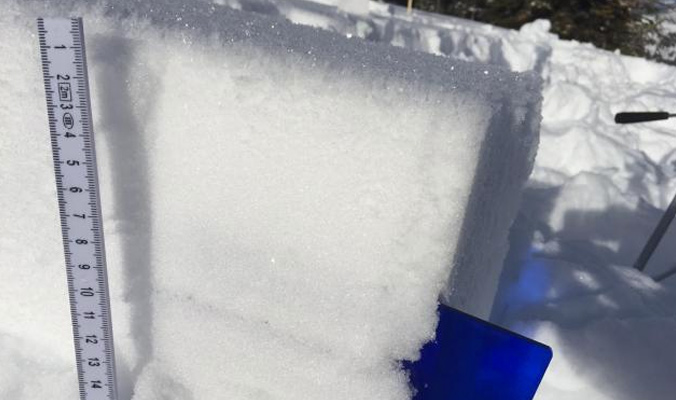
!["A block from a snowpack test turned upside down to view the buried surface hoar." [Photo] Courtesy CAIC](https://backcountrymagazine.com/wp-content/uploads/2017/02/jan_29_embed_1.jpg)
“A block from a snowpack test turned upside down to view the buried surface hoar.” [Photo] Courtesy CAIC
Northwest Avalanche Center (NWAC)
Much like Colorado, the primary weak layer across the area under the purview of the NWAC is a result of windslab accumulating on top of recently formed surface hoar. This instability is especially sensitive in the Mt. Baker region.
“Specifically in the Mt. Baker area, be aware of a higher likelihood of triggering windslab where it overlies recently buried surface hoar,” The NWAC reports on Tuesday, January 31. “Field observations suggest this setup exists in isolated areas on northerly aspects near tree line in the Mt. Baker backcountry.”
This instability is fairly widespread and the reason for the moderate avy danger rating across the NWAC forecasting region.
To find out more about conditions in the Pacific Northwest, visit www.nwac.us.
Utah Avalanche Center (UAC)
Danger ratings have generally subsided over the past few weeks in Utah, with the current rating listed as moderate for all aspects and elevations in all regions, except the southwest aspects near and below tree line in the Uintas and all but the northeast aspects above tree line for Skyline (which are rated as low). The moderate danger rating is due to persistent slab at mid elevations and windslabs above tree line. The UAC also cautions that wet slides could occur in the afternoon when the snowpack heats up.
![A thick layer of buried surface hoar found in Toll Canyon, Utah. [Photo] Courtesy UAC](https://backcountrymagazine.com/wp-content/uploads/2017/02/hoar_embed_jan_29.jpg)
A thick layer of buried surface hoar found in Toll Canyon, Utah. [Photo] Courtesy UAC
Gallatin National Forest Avalanche Center (GNFAC)
With two to four inches of new snow coming in across the GNFAC region at the beginning of the week—some areas are seeing upward of seven inches—the avy danger is rising to considerable. More snow is predicted overnight and at least a foot of snow is forecasted to arrive by the end of this storm cycle. This new snow falls on sugary facets that are usually being reported at the bottom of the snowpack in the GNFAC region, although in some areas, the entire snowpack is faceted. And with wind accompanying the storm this week, storm slabs are the primary concern.
An image showing surface hoar buried 10 centimeters down and then the surface hoar on the surface that was buried from a snowfall on Tuesday, January 31. Photo: K. Birkeland, courtesy GNFAC
To find out more about conditions in Montana, visit www.mtavalanche.com.
Bridger Teton National Forest Avalanche Center (BTAC)
The BTAC is reporting moderate avalanche danger at all aspects and elevations under their purview. This rating is a result of extremely high winds ranging from 55 to 95 miles per hour in some locations. Windslabs are the primary concern, and with new snow on its way, the danger may increase into Wednesday, February 1.
“Pockets of windslab could be human triggered in steep avalanche prone terrain,” Warns the BTAC. “These slabs could fail on buried surface hoar, sun crusts and old wind-packed snow surfaces. Monitor conditions and be ready to adjust plans if you observe indications that the avalanche hazard is rapidly increasing.”
To find out more about conditions in Wyoming, visit www.jhavalanche.org.
Sierra Avalanche Center (SAC)
In the Sierra, a period of relatively stable conditions has reached the area. But while avalanche danger is rated low as of Tuesday, January 31, the SAC reminds bc travelers to stay alert and aware of avalanche conditions and terrain.
“Isolated areas of instability may exist,” the SAC cautions. “Use normal caution while traveling in the backcountry by utilizing the accepted best practice travel techniques for travel in or below avalanche terrain.”
To find out more about conditions in California, visit http://www.sierraavalanchecenter.org.
—
As the winter progresses, it’s important to keep an eye on snowpack trends and instabilities. This is not a complete guide to avalanche forecasts, so stay informed and educated by visiting local avalanche forecasting websites and get educated about avalanche safety through programs like Know Before You Go, the Mountain Academy hosted by Salomon and Atomic and through nationwide courses offered by the American Institute for Avalanche Research and Education (AIARE).


Related posts: