Avalanche forecast centers do a great job informing backcountry travelers about current conditions, weather patterns and the avalanche danger. In fact, when you start digging, there is a huge amount of information on an avalanche forecast center’s website. But to get the most out of the forecast and prioritize information, don’t just stop at the danger rating—use the forecast center’s site as a resource regarding past, current and future conditions.
Here’s how to get the most out of the avalanche forecast.
DON’T JUST READ THE DANGER RATING
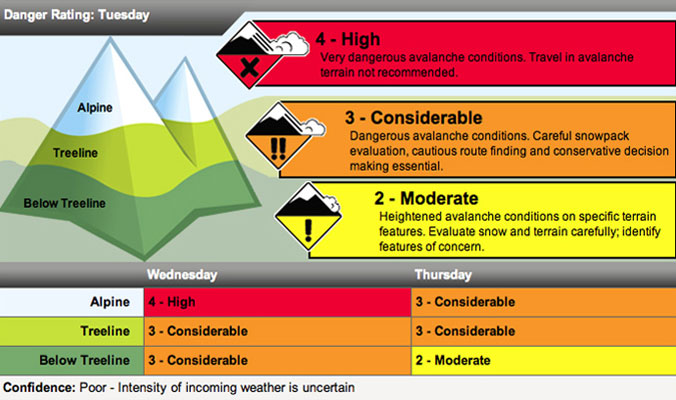
The first thing on a center’s site is the current avalanche danger—low, moderate, considerable, high, extreme. Don’t stop once you’ve read that rating.
Along with each rating is travel advice, as well as information on the likelihood of avalanches and where they may be found. For example, moderate danger, by definition, means there are heightened avalanche conditions on specific terrain features—natural avalanches are unlikely and human-triggered avalanches are possible. This means that one can find either small avalanches in specific areas or large avalanches in isolated areas.
Since the consequences of small and large avalanches can be very different, you have to dig deeper, beyond just the danger rating, in order to understand what moderate danger means for your day.
UNDERSTAND THE NATURE OF THE PROBLEM
Forecast centers will often refer to the avalanche problem—storm slab, wind slab, persistent slab, deep slab, etc. Different problems require different management techniques and different terrain choices.
Identify the avalanche problem(s) for the day, as this should help guide your route for the day. If it’s a year where the problem is persistent or deep slabs, use extra caution. These problems are hard to predict and can fool everyone, even the most seasoned veteran.
KNOW IF THERE’S BEEN AVALANCHE ACTIVITY IN THE LAST 48 HOURS
Avalanche activity is Mother Nature screaming in your ear that instability exists. Therefore, seek out information about avalanche activity in your local area. If there has been recent avalanche activity, understand where it is taking place—what aspect, what elevation, what weak layer. Consider how conditions have changed since the most recent reported avalanche activity and use this information to determine your terrain choices for the day.
UNDERSTAND PAST, PRESENT AND FUTURE WEATHER
Weather creates the snowpack, which means that weather has a big influence on avalanche hazard. Seek out weather data on the forecast center’s sites or follow links to local weather stations. When studying the past weather, ask yourself the following:
- How much snow has fallen in the last 24 to 48 hours? If it’s greater than 12 to 18 inches, the hazard has likely increased.
- Has the wind been blowing? If yes, what direction has it been blowing from? How fast? For how long? Wind can move up to 10 times the amount of snow that can fall from the sky. Know where it is moving the snow.
- What is the weather doing now? Is this different than the last 24 hours? Is the hazard decreasing or increasing?
- What is the weather forecast for the day? If the weather is forecasted to continue in the same trend as the previous 24 hours, you have some good information to go on regarding changing stability. If it has been snowing for 48 hours and is forecasted to snow for the next 24 hours, you can assume that it is going to be a powder day and that the avalanche hazard is not decreasing in the next 24 hours and will likely increase.
LOOK FOR TRAVEL ADVICE
Forecasters often add commentary to their forecasts. Read it. There are words of wisdom in there, and there’s often advice about terrain to avoid.
Reading the avalanche forecast should be the start of your day. Once you’ve read it, you can choose terrain that is appropriate for the hazard, as well as for your group. Remember that the forecast is just that…a forecast, not the law of the land.
Avalanche forecasters are issuing a danger rating for large areas in the mountains, and many variables, including terrain features, terrain positioning relative to storm tracks and local weather patterns, can influence slope-scale hazard.
The forecast that the avalanche center issues should be used as a hypothesis for your travel day. Test it while you are in the field and prove or disprove the hazard rating through snow and weather observations. If it’s not adding up, adjust your route and report your finding back to the center. And if you’re ever in doubt, choose simpler terrain.
—
Sarah Carpenter is the co-owner of the American Avalanche Institute and an AMGA-certified ski guide. Her first job out of college was ski patrolling at Bridger Bowl, Mont., and she’s been working in the snow and avalanche industry ever since as a patroller, ski guide and avalanche educator.






Related posts:
Mountain Skills: Skiing with Sharp Objects
Food Fight: Can What You Eat Earn You Another Lap Up The Skintrack?
The Snow Pro: Janelle Smiley talks the art of efficiency
Mountain Skills: Why good ski partners matter