“My map and compass never have dead batteries.” This is the most common rationale I hear for not learning and adopting new technology. Film still works in cameras and the Postal Service still gets information from place to place, but there are better ways these days. The same is true for improving the way we tour plan and navigate.
Every day that I go in the backcountry I want to make a plan, avoid unnecessary hazards, travel efficiently, not lose my way and learn from the experience so mine, and that of others, will be better in the future. Today’s technology has evolved to a point where, without special software or devices, most of us can accomplish this using devices we already own and use on a daily basis.
I regularly use Hillmap, Google Earth and GaiaGPS, and while there are many similar services available, these are the ones I’m most familiar with. In general, the process is more important than the tools.
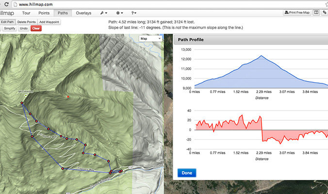
Hillmap offers a handful of tour-planning tools from distance and elevation information to slope angles and links to weather sites.
Make a Plan
Every tour plan should consist of two ingredients: a destination and terrain to avoid. For example, the goal is to ski from the summit of Mt. Emmons (see above) while avoiding large avalanche paths due to elevated hazard. With these parameters it is possible to draw a specific route on a topo map. While both Hillmap and GaiaGPS will work at this step, I prefer to start with Hillmap because it has more tools available, like the ability to measure slope angle and connect to local Snotel sites.
Next, create a .kml file and open it in Google Earth. Make sure your intended route accomplishes your goal, has you traveling in the simplest terrain possible and avoids unnecessary hazards.
If you like your plan, create a .gpx file and send it to GaiaGPS. Use the data to finish your tour plan by making time estimates for all the legs of your trip. This route should be easy to follow in the field, even without a cellular connection. Download the appropriate base maps to your device for your tour.
Returning to Hillmap will allow you to print a custom map. Use waterproof paper and take it with you into the field as a backup, or if you don’t want to get out your mobile device.
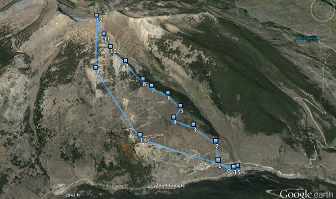
Exporting a route to Google Earth as a .kml file allows you to see if you’ve stayed out of hazardous areas, to plan to travel through the path of least resistance and to anticipate tricky spots.
Follow Your Route, But Not Blindly
Turn off your cellular connections so you use as little battery as possible. The GPS function on a mobile device works independently of cell service and, in most devices, is incredibly accurate. Your exact location, along with a track of the path traveled, will be displayed on the downloaded map. Obviously, this should help you stay on route and will be very helpful getting back on course if you took a wrong turn.
Beyond this, GaiaGPS allows you to collect data that’s automatically tied to your location. You can take a photo of a landmark to make navigation easier in the future, and snap shots of avalanche activity or of snow conditions.
The key is to use the tools available without forgetting to be observant of your surroundings. Don’t follow your “little blue dot” right into a tree well…you’ll never hear the end of it.
Review the Day
At the end of the day, compare the track taken with your intended route. There are often variations and they might have been mistakes or improvements. Take note of these and create a new route for future travel. Going back will be easier.
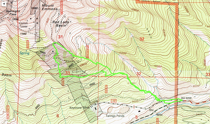
This is my track from the day on Mt. Emmons. We didn’t summit because of snow conditions and turned around to ski in the trees. On the descent, we found a road, which may be a better and less steep way to ascend next time.
All technology today is based on the concept of sharing. Consider uploading your data to social media and the GaiaGPS website or sending it to friends so they can follow your track. Maybe you want to keep your powder stash to yourself, but consider sharing your observations with your local avalanche center. Photos of avalanche activity and snow conditions are invaluable to the forecasters writing the bulletin, and they’re after your observations, not your stash.
Of course, in a real pinch, you don’t want to rely on an electronic device with batteries. (Heck, you’ll never be able to start a fire with your iPhone.) But it’s hard to argue with inexpensive services—which operate on devices we use everyday—that can help us plan ahead, stay out of trouble and share information easily.
—
Donny Roth is an AMGA-certified ski guide and professional skier. He writes about his adventures at independent-descents.com. Learn more about skiing with him in Chile at chile-powder-adventures.com.
Related posts: