
This week in the western U.S., slab avalanches are a widespread concern for skiers and riders heading into the backcountry. With high winds affecting regions from Colorado to California and all the way north to Montana, near and above tree line skiing is a potentially dangerous proposition. Here is this week’s report to help guide you in your terrain decisions in the coming days.
Crested Butte Avalanche Center (CBAC)/Colorado Avalanche Information Center (CAIC)
Low-density snow and wind are generally a combination that can bring unwanted windslab instabilities and, this week in Colorado, this unfortunate pairing is pervasive. With up to 10 inches of snow falling over the weekend in some areas of Colo., there’s heightened possibility of slabs forming on northwest-to-northeast aspects near and above tree line. The CAIC warns that wind drifts can form on top of old slab and can make it difficult to identify wind-related avy warning signs.
“Underneath the fresh wind drifts, older drifts sit on persistent weak layers,” the CAIC explains. “It is still possible for you to trigger large avalanches in previously wind-loaded areas, particularly just below ridgelines. These could break on weak, small-grained, faceted crystals buried one- to three-feet deep.”
This primary instability is the reason for the avalanche danger rating of moderate throughout Colorado, except for the southernmost regions of the Southern San Juan Mountains and the Sangre de Cristo Mountains, which are rated as low as of Tuesday.
Find out more about Colorado avalanche conditions at avalanche.state.co.us and cbavalanchecenter.org.
Northwest Avalanche Center (NWAC)
The week of Valentines Day brought a low-pressure system to the Northwest and, with it, lots of rain. Following the formation of a rain-crust layer, light snow fell across the region, accompanied by winds that formed slabs primarily on northwest through southeast slopes throughout the areas under NWAC’s purview. The resulting windslabs are responsible for moderate avalanche-danger ratings near and above tree line. This rating can be found everywhere except for the southern regions of Cascades West and Mt. Hood, which are rated as considerable as of Tuesday. That rating is due to the potential for windslab instabilities on aspects near and above tree line.
“A backcountry report from NWAC pro-observer Laura Green from the White River drainage on Friday indicated a mix of surface conditions,” the NWAC reports on Tuesday. “Below tree line she found plenty of roller balls. Near and above tree line she found a firm rain crust with varying amounts of recent snow above depending upon wind exposure. Isolated windslabs had formed on the leeward terrain below ridges, with one natural windslab at about 7,700 feet on an east/southeast-facing wind-loaded slope. Elsewhere she found firm conditions on an exposed hard rain crust.”
It’s a mixed bag out there in the Pacific Northwest right now, so make sure to pick terrain wisely.
Find out more about conditions in the Pacific Northwest at nwac.us.
Utah Avalanche Center (UAC)
The winds keep on howling in Utah. With gusts clocking in at anywhere from 30 to 70 mph, windslab is the primary instability to look for. Natural avalanches are possible at higher elevations and have, in some cases, been triggered by cornice fall.
“Once again, with the strong winds, reports from the Ogden area mountains of three large natural avalanches triggered by cornice fall on upper elevation slopes on the windy high ridge lines,” the UAC explains. “These were D2 (or slightly larger—big enough to kill a person) with crowns two- to four-feet deep. Off the ridges, windslabs were released by explosives and ski cuts, mostly on northeast and east-facing terrain. Transport occurred at mid elevations, too. Wet, loose sluffs, large enough to catch a person, were also reported.
Storm snow with high water content is also cause for concern in the northern regions under UAC’s purview, with multiple people submitting reports of triggering heavy, wet sluffs in the Logan area.
Overall, the avy danger is considerable for all regions except for the Skyline area, which is low below and at tree line, with moderate danger above tree line, with similar wind-drift issues to the rest of Utah.
Find out more about conditions in Utah at utahavalanchecenter.org.
Gallatin National Forest Avalanche Center (GNFAC)
In Montana, avalanche danger ratings currently range from low to high. The Northern Gallatin Range is experiencing a period of relative stability, with no new snow in recent days to create issues. But the story is very different in the southern areas under GNFAC’s purview, where a few inches of very dense, waterlogged snow have elevated the avalanche danger to high. This snow is falling on a weak, facet layer that could give way under the weight of the fresh precipitation.
In the central Bridger and Madison Ranges, avy danger is currently moderate due to five to six inches of wind-whipped snow that fell over the weekend.
“The five to six inches that fell on Sunday in the Bridger Range blew into drifts that have become harder to trigger,” the GNFAC reports Tuesday. “Around Big Sky, a layer of weak snow (facets) 1.5-to-two-feet deep are breaking clean in stability tests. Although we have not seen avalanche activity on this layer, we do not trust it.”
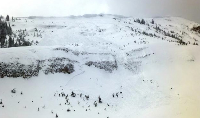
Windloaded slopes in the Lionhead region are particularly avalanche prone currently. [Photo] Courtesy GNFAC
Bridger Teton National Forest Avalanche Center (BTAC)
Much like the lower regions of the GNFAC, the BTAC is also experiencing the effects of dense precipitation falling with the added influence of wind. Dense slabs at mid and upper elevations pose the primary hazard in the Tetons, and skier-triggered avalanches have been reported over the past few days in and around Jackson Hole Mountain Resort. Consequently, the avy danger is high for Tuesday. In the Togwotee Pass and Greys River regions, similar issues exist but to a lesser degree, with the danger for all elevations listed as considerable.
Find out more about conditions in Wyoming at jhavalanche.org.
Sierra Avalanche Center (SAC)
In the Central Sierra Nevada Mountains, the avalanche danger is high for all elevations. This danger is due to windslabs that have formed in the past few days on almost all aspects. The SAC warns on Tuesday, “Travel in or below avalanche terrain is not advised. Avoid avalanche runout zones.”
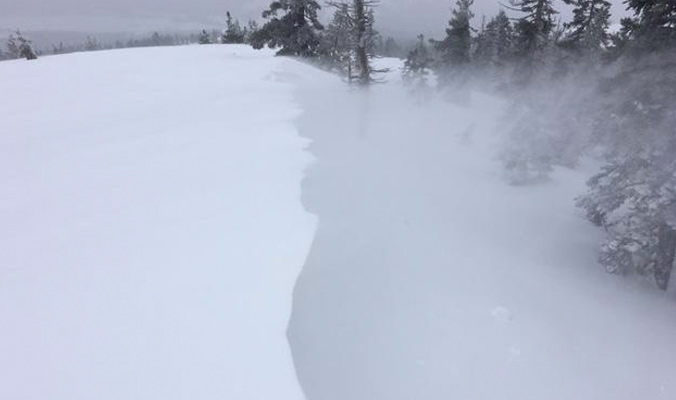
Windslab formation in the Sierra. [Photo] Courtesy SAC
—
As the winter progresses, it’s important to keep an eye on snowpack trends and instabilities. This is not a complete guide to avalanche forecasts, so stay informed and educated by visiting local avalanche forecasting websites and get educated about avalanche safety through programs like Know Before You Go, the Mountain Academy hosted by Salomon and Atomic and through nationwide courses offered by the American Institute for Avalanche Research and Education (AIARE).


Related posts: